2015/01/31

SMAP Takes to the Skies


A United Launch Alliance Delta II rocket with the Soil Moisture Active Passive (SMAP) observatory onboard is seen in this long exposure photograph as it launches from Space Launch Complex 2, Saturday, Jan. 31, 2015, Vandenberg Air Force Base, Calif. SMAP is NASA’s first Earth-observing satellite designed to collect global observations of surface soil moisture and its freeze/thaw state. SMAP will provide high resolution global measurements of soil moisture from space. The data will be used to enhance scientists' understanding of the processes that link Earth's water, energy, and carbon cycles. Photo Credit: (NASA/Bill Ingalls) via NASA http://ift.tt/1Abg9qy

A Night at Poker Flat


Four NASA suborbital sounding rockets leapt into the night on January 26, from the University of Alaska's Poker Flat Research Range. This time lapse composite image follows all four launches of the small, multi-stage rockets to explore winter's mesmerizing, aurora-filled skies. During the exposures, stars trailed around the North Celestial Pole, high above the horizon at the site 30 miles north of Fairbanks, Alaska. Lidar, beams of pulsed green lasers, also left traces through the scene. Operating successfully, the payloads lofted were two Mesosphere-Lower Thermosphere Turbulence Experiments (M-TeX) and two Mesospheric Inversion-layer Stratified Turbulence (MIST) experiments, creating vapor trails at high altitudes to be tracked by ground-based observations. via NASA http://ift.tt/1LoEhJN

2015/01/30

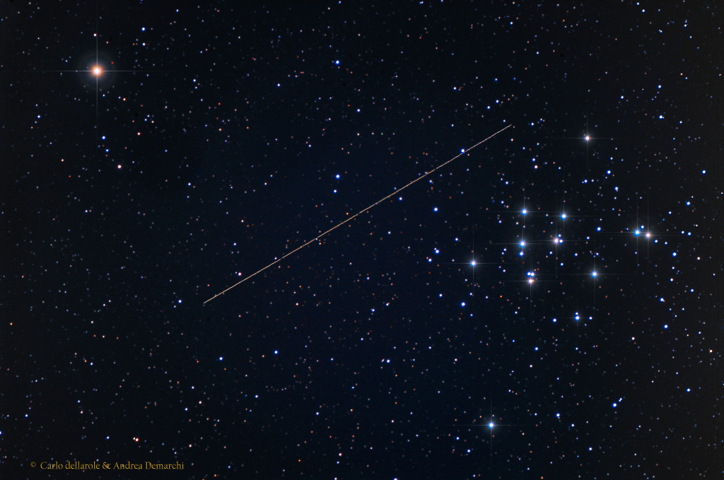
Close Encounter with M44


On Monday, January 26, well-tracked asteroid 2004 BL86 made its closest approach, a mere 1.2 million kilometers from our fair planet. That's about 3.1 times the Earth-Moon distance or 4 light-seconds away. Moving quickly through Earth's night sky, it left this streak in a 40 minute long exposure on January 27 made from Piemonte, Italy. The remarkably pretty telescopic field of view includes M44, also known as the Beehive or Praesepe star cluster in Cancer. Of course, its close encounter with M44 is only an apparent one, with the cluster nearly along the same line-of-sight to the near-earth asteroid. The actual distance between star cluster and asteroid is around 600 light-years. Still, the close approach to planet Earth allowed detailed radar imaging from NASA's Deep Space Network antenna at Goldstone, California and revealed the asteroid to have its own moon. via NASA http://ift.tt/1uDIdf4

2015/01/29

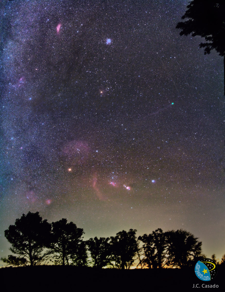
Comet Lovejoy in a Winter Sky


Which of these night sky icons can you find in this beautiful and deep exposure of the northern winter sky? Skylights include the stars in Orion's belt, the Orion Nebula, the Pleiades star cluster, the bright stars Betelgeuse and Rigel, the California Nebula, Barnard's Loop, and Comet Lovejoy. The belt stars of Orion are nearly vertical in the central line between the horizon and the image center, with the lowest belt star obscured by the red glowing Flame Nebula. To the belt's left is the red arc of Barnard's Loop followed by the bright orange star Betelgeuse, while to the belt's right is the colorful Orion Nebula followed by the bright blue star Rigel. The blue cluster of bright stars near the top center is the Pleiades, and the red nebula to its left is the California nebula. The bright orange dot above the image center is the star Aldebaran, while the green object with the long tail to its right is Comet C/2014 Q2 (Lovejoy). The featured image was taken about two weeks ago near Palau village in Spain. via NASA http://ift.tt/18sBKzc

2015/01/28

NASA's Soil Moisture Active Passive (SMAP) Ready for Jan. 29 Launch


The sun sets behind Space Launch Complex 2 (SLC-2) with the Delta II rocket and the Soil Moisture Active Passive (SMAP) observatory protected by the service structure on Tuesday, Jan. 27, 2015, at Vandenberg Air Force Base, Calif. SMAP is NASA’s first Earth-observing satellite designed to collect global observations of surface soil moisture and its freeze/thaw state. SMAP will provide high resolution global measurements of soil moisture from space. The data will be used to enhance scientists' understanding of the processes that link Earth's water, energy, and carbon cycles. Image Credit: NASA/Bill Ingalls via NASA http://ift.tt/1zyp1a3

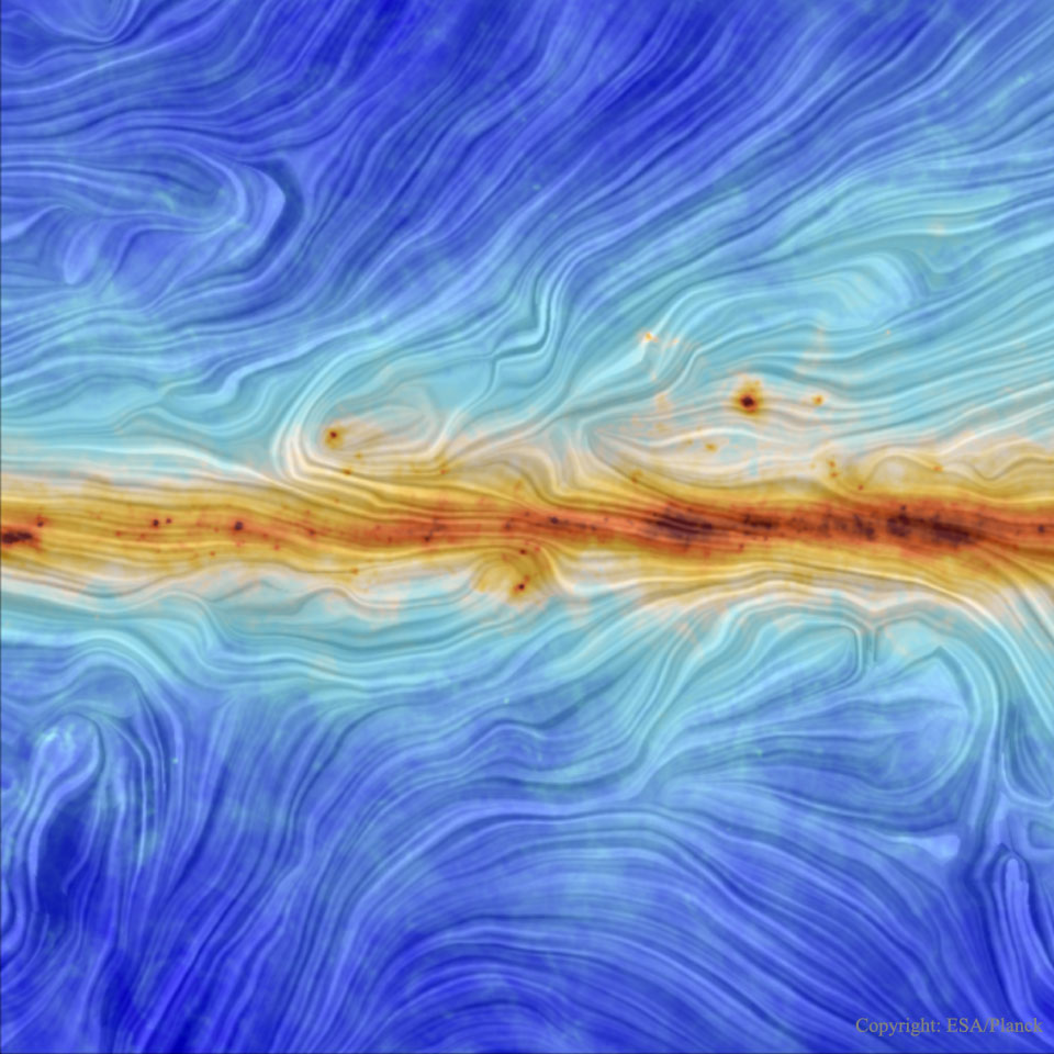
Our Galaxys Magnetic Field from Planck


What does the magnetic field of our Galaxy look like? It has long been known that a modest magnetic field pervades our Milky Way Galaxy because it is seen to align small dust grains that scatter background light. Only recently, however, has the Sun-orbiting Planck satellite made a high-resolution map of this field. Color coded, the 30-degree wide map confirms, among other things, that the Galaxy's interstellar magnetism is strongest in the central disk. The revolution of charged gas around the Galactic center creates this magnetism, and it is hypothesized that viewed from the top, the Milky Way's magnetic field would appear as a spiral swirling out from the center. What caused many of the details in this and similar Planck maps -- and how magnetism in general affected our Galaxy's evolution -- will likely remain topics of research for years to come. via NASA http://ift.tt/1uVSucf

2015/01/27

Sounding Rockets Launch Into an Aurora


The interaction of solar winds and Earth’s atmosphere produces northern lights, or auroras, that dance across the night sky and mesmerize the casual observer. However, to scientists this interaction is more than a light display. It produces many questions about the role it plays in Earth’s meteorological processes and the impact on the planet’s atmosphere. To help answer some of these questions, NASA suborbital sounding rockets carrying university-developed experiments -- the Mesosphere-Lower Thermosphere Turbulence Experiment (M-TeX) and Mesospheric Inversion-layer Stratified Turbulence (MIST) -- were launched into auroras from the Poker Flat Research Range in Alaska. The experiments explore the Earth’s atmosphere’s response to auroral, radiation belt and solar energetic particles and associated effects on nitric oxide and ozone. This composite shot of all four sounding rockets for the M-TeX and MIST experiments is made up of 30 second exposures. The rocket salvo began at 4:13 a.m. EST, Jan. 26, 2015. A fifth rocket carrying the Auroral Spatial Structures Probe remains ready on the launch pad. The launch window for this experiment runs through Jan. 27. Image Credit: NASA/Jamie Adkins > More: M-TeX and MIST Experiments Launched from Alaska via NASA http://ift.tt/1yL9zFf

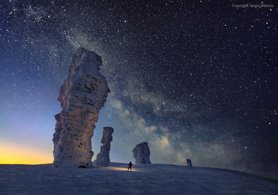
The Milky Way over the Seven Strong Men Rock Formations


You may have heard of the Seven Sisters in the sky, but have you heard about the Seven Strong Men on the ground? Located just west of the Ural Mountains, the unusual Manpupuner rock formations are one of the Seven Wonders of Russia. How these ancient 40-meter high pillars formed is yet unknown. The persistent photographer of this featured image battled rough terrain and uncooperative weather to capture these rugged stone towers in winter at night, being finally successful in February of last year. Utilizing the camera's time delay feature, the photographer holds a flashlight in the foreground near one of the snow-covered pillars. High above, millions of stars shine down, while the band of our Milky Way Galaxy crosses diagonally down from the upper left. via NASA http://ift.tt/1CWiaUQ

2015/01/26

Rocky Mountain National Park Viewed From the International Space Station


Marking the 100th anniversary of the Rocky Mountain National Park on Jan. 26, 2015, Expedition 42 Flight Engineer Terry Virts posted this photograph, taken from the International Space Station, to Twitter. Virts wrote, "Majestic peaks and trails! Happy 100th anniversary @RockyNPS So much beauty to behold in our @NatlParkService." Image Credit: NASA/Terry Virts via NASA http://ift.tt/1JtMz0Y

A Twisted Solar Eruptive Prominence


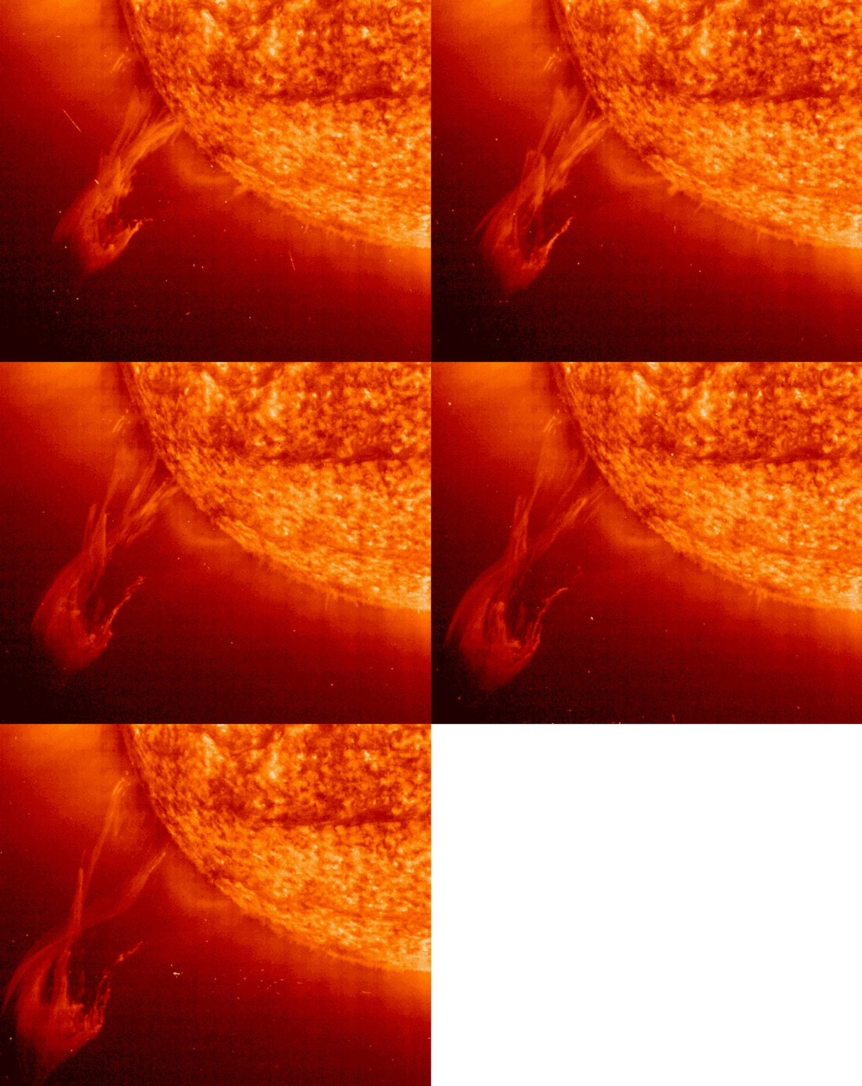
Ten Earths could easily fit in the "claw" of this seemingly solar monster. The monster, actually a huge eruptive prominence, is seen moving out from our Sun in this condensed half-hour time-lapse sequence. This large prominence, though, is significant not only for its size, but its shape. The twisted figure eight shape indicates that a complex magnetic field threads through the emerging solar particles. Differential rotation of gas just inside the surface of the Sun might help account for the surface explosion. The five frame sequence was taken in early 2000 by the Sun-orbiting SOHO satellite. Although large prominences and energetic Coronal Mass Ejections (CMEs) are relatively rare, they are again occurring more frequently now that we are near the Solar Maximum, a time of peak sunspot and solar activity in the eleven-year solar cycle. via NASA http://ift.tt/1JE3Nam

2015/01/25

Light from Cygnus A


Celebrating astronomy in this International Year of Light, the detailed image reveals spectacular active galaxy Cygnus A in light across the electromagnetic spectrum. Incorporating X-ray data (blue) from the orbiting Chandra Observatory, Cygnus A is seen to be a prodigious source of high energy x-rays. But it is actually more famous at the low energy end of the electromagnetic spectrum. One of the brightest celestial sources visible to radio telescopes, at 600 million light-years distant Cygnus A is the closest powerful radio galaxy. Radio emission (red) extends to either side along the same axis for nearly 300,000 light-years powered by jets of relativistic particles emanating from the galaxy's central supermassive black hole. Hot spots likely mark the ends of the jets impacting surrounding cool, dense material. Confined to yellow hues, optical wavelength data of the galaxy from Hubble and the surrounding field in the Digital Sky Survey complete a remarkable multiwavelength view. via NASA http://ift.tt/1CMqypR

2015/01/24

Interior View


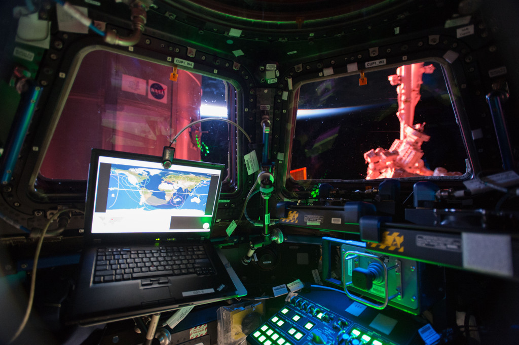
Some prefer windows, and these are the best available on board the International Space Station. Taken on January 4, this snapshot from inside the station's large, seven-window Cupola module also shows off a workstation for controlling Canadarm2. Used to grapple visiting cargo vehicles and assist astronauts during spacewalks, the robotic arm is just outside the window at the right. The Cupola itself is attached to the Earth-facing or nadir port of the station's Tranquility module, offering dynamic panoramas of our fair planet. Seen from the station's 90 minute long, 400 kilometer high orbit, Earth's bright limb is in view above center. via NASA http://ift.tt/1JqrMcN

2015/01/23

Launch to Lovejoy


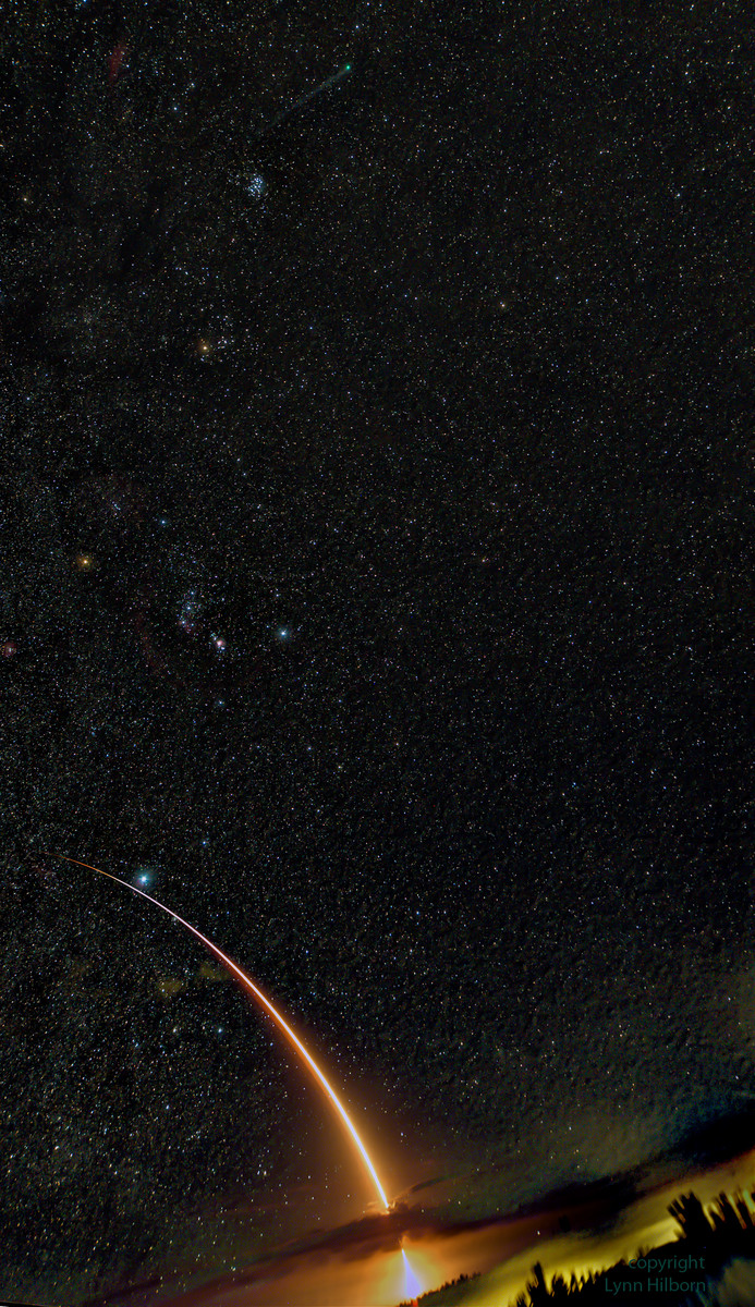
Blasting skyward an Atlas V rocket carrying a U.S. Navy satellite pierces a cloud bank in this starry night scene captured on January 20. On its way to orbit from Space Launch Complex 41, Cape Canaveral Air Force Station, planet Earth, the rocket streaks past brightest star Sirius, as seen from a dark beach at Canaveral National Seashore. Above the alpha star of Canis Major, Orion the Hunter strikes a pose familiar to northern winter skygazers. Above Orion is the V-shaped Hyades star cluster, head of Taurus the Bull, and farther still above Taurus it's easy to spot the compact Pleiades star cluster. Of course near the top of the frame you'll find the greenish coma and long tail of Comet Lovejoy, astronomical darling of these January nights. via NASA http://ift.tt/1ChS00P

2015/01/22

Greenland's Leidy Glacier


Located in the northwest corner of Greenland, Leidy Glacier is fed by ice from the Academy Glacier (upstream and inland). As Leidy approaches the sea, it is diverted around the tip of an island that separates the Olriks Fjord to the south and Academy Cove to the north. The resulting crisscross pattern is simply the result of ice flowing along the path of least resistance. This view of the region pictured above was acquired August 7, 2012, by the Advanced Spaceborne Thermal Emission and Reflection Radiometer (ASTER) on NASA's Terra satellite. In April 2012, the feature caught the attention of a NASA pilot, who snapped this picture from the cockpit of a high-flying ER-2 aircraft during a research flight over the Greenland ice cap. More information. Image Credit: NASA/Terra via NASA http://ift.tt/1xDQdxZ

The Complex Ion Tail of Comet Lovejoy


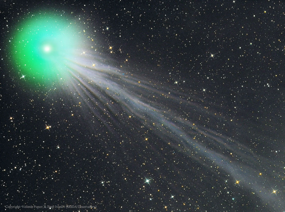
What causes the structure in Comet Lovejoy's tail? Comet C/2014 Q2 (Lovejoy), which is currently at naked-eye brightness and near its brightest, has been showing an exquisitely detailed ion tail. As the name implies, the ion tail is made of ionized gas -- gas energized by ultraviolet light from the Sun and pushed outward by the solar wind. The solar wind is quite structured and sculpted by the Sun's complex and ever changing magnetic field. The effect of the variable solar wind combined with different gas jets venting from the comet's nucleus accounts for the tail's complex structure. Following the wind, structure in Comet Lovejoy's tail can be seen to move outward from the Sun even alter its wavy appearance over time. The blue color of the ion tail is dominated by recombining carbon monoxide molecules, while the green color of the coma surrounding the head of the comet is created mostly by a slight amount of recombining diatomic carbon molecules. The featured three-panel mosaic image was taken nine days ago from the IRIDA Observatory in Bulgaria. Comet Lovejoy made it closest pass to the Earth two weeks ago and will be at its closest to the Sun in about ten days. After that, the comet will fade as it heads back into the outer Solar System, to return only in about 8,000 years. via NASA http://ift.tt/1xwpV0r

2015/01/21

Fjord in East Greenland Seen by NASA's Operation IceBridge


This view of the frozen fjord downstream of Violingletscher (Violin Glacier) in Østgrønland (East Greenland) was seen during an Operation IceBridge survey flight on April 5, 2014. NASA’s Operation IceBridge images Earth's polar ice in unprecedented detail to better understand processes that connect the polar regions with the global climate system. IceBridge utilizes a highly specialized fleet of research aircraft and the most sophisticated suite of innovative science instruments ever assembled to characterize annual changes in thickness of sea ice, glaciers, and ice sheets. In addition, IceBridge collects critical data used to predict the response of earth’s polar ice to climate change and resulting sea-level rise. IceBridge also helps bridge the gap in polar observations between NASA's ICESat satellite missions. > Read more about IceBridge's 2014 Arctic campaign Image Credit: NASA/Michael Studinger via NASA http://ift.tt/1lI0OUg

Snow-Covered Desert


Snow-covered deserts are rare, but that's exactly what the Moderate Resolution Imaging Spectroradiometer (MODIS) on NASA's Aqua satellite observed as it passed over the Taklimakan Desert in western China on Jan. 2, 2013. Snow has covered much of the desert since a storm blew through the area on Dec. 26. The day after the storm, Chinese Central Television (CNTV) reported that the Xinjian Uygyr autonomous region was one of the areas hardest hit. The Taklimakan is one of the world's largest-and hottest-sandy deserts. Water flowing into the Tarim Basin has no outlet, so over the years, sediments have steadily accumulated. In parts of the desert, sand can pile up to 300 meters (roughly 1,000 feet) high. The mountains that enclose the sea of sand-the Tien Shan in the north and the Kunlun Shan in the south-were also covered with what appeared to be a significantly thicker layer of snow in January 2013. Image Credit: NASA/Aqua via NASA http://ift.tt/VkSLyF

Fifteen Years Ago, Chandra X-Ray Observatory Deployed by Space Shuttle Crew


On July 23, 1999, a little more than seven hours after Space Shuttle Columbia and its five astronauts were launched from the Kennedy Space Center, NASA's Chandra X-Ray Observatory was successfully deployed by the STS-93 crew. Chandra was spring-ejected from a cradle in the shuttle’s cargo bay at 6:47 a.m. Central time, as Columbia flew over the Indonesian island chain. Commander Eileen Collins, the first female Shuttle Commander, maneuvered Columbia to a safe distance away from the telescope as an internal timer counted down to the first of a two-phase ignition of the solid-fuel Inertial Upper Stage (IUS). The IUS lit up as scheduled at 7:47 a.m., and a few minutes later, shut down as planned, sending Chandra on a highly elliptical orbit which was refined over the next few weeks by a series of firings of telescope thrusters, designed to place Chandra in an orbit about 6900 x 87,000 statute miles above the Earth. Since its deployment, Chandra has helped revolutionize our understanding of the universe through its unrivaled X-ray vision. Chandra, one of NASA's current "Great Observatories," along with the Hubble Space Telescope and Spitzer Space Telescope, is specially designed to detect X-ray emission from hot and energetic regions of the universe. In this photograph, the five STS-93 astronauts pose for the traditional inflight crew portrait on Columbia's middeck. In front are astronauts Eileen M. Collins, mission commander, and Michel Tognini, mission specialist representing France's Centre National d'Etudes Spatiales (CNES). Behind them are (from the left) astronauts Steven A. Hawley, mission specialist; Jeffrey S. Ashby, pilot; and Catherine G. (Cady) Coleman, mission specialist. In the background is a large poster depicting the Chandra X-Ray Observatory. Image Credit: NASA via NASA http://ift.tt/1A60XJ8

NASA's GROVER Debuts On Greenland's Ice Sheet


NASA's new Earth-bound rover began testing on the Greenland ice sheet this week. GROVER, which stands for both Greenland Rover and Goddard Remotely Operated Vehicle for Exploration and Research, is an autonomous, solar-operated robot that carries a ground-penetrating radar to examine the layers of Greenland's ice sheet. Its findings will help scientists understand how the massive ice sheet gains and loses ice. The GROVER team, led by glaciologist Lora Koenig from NASA's Goddard Space Flight Center in Greenbelt, Md., arrived in Summit Camp, the highest spot in Greenland, on May 6, 2013. After loading and testing the rover's radar and fixing a minor communications glitch, the team began the robot's tests on the ice on May 8, defying winds of up to 23 mph (37 kph) and temperatures as low as minus 22 F (minus 30 C). The GROVER tests will continue through June 8. GROVER, a prototype, was first developed in 2010 and 2011 during summer engineering boot camps at Goddard, before further refinement, with NASA funding, at Boise State University. Its trial in Greenland will also serve as a test of using rovers in harsh polar regions to gather data. › Read More Image Credit: Lora Koenig / NASA Goddard via NASA http://ift.tt/179tmRF

Astronaut Reid Wiseman Shares Earth Art While Preparing for Return


NASA astronaut Reid Wiseman shared this image of Yellowstone via his twitter account this morning. Wiseman later tweeted: "We cranked up our #Soyuz this morning and test fired all the thrusters. Everything worked flawlessly - ready for a Sunday departure." - @astro_reid The homebound Expedition 40/41 trio, consisting of Soyuz Commander Max Suraev and Flight Engineers Alexander Gerst and Wiseman, is counting down to its Nov. 9 departure inside the Soyuz TMA-13M spacecraft. They are packing gear to be returned home while they continue science and maintenance on the U.S. side of the International Space Station. Back on Earth, the new Expedition 42/43 crew is getting ready for its launch to the space station from the Baikonur Cosmodrome in Kazakhstan on Nov. 23. Soyuz Commander Anton Shkaplerov will be joined by NASA astronaut Terry Virts and European Space Agency astronaut Samantha Cristoforetti aboard a Soyuz TMA-15M spacecraft to begin a 5-1/2 month mission aboard the orbital laboratory. Space Station Blog Image Credit: NASA/Reid Wiseman via NASA http://ift.tt/1zAm7QT

Lunar Atmosphere and Dust Environment Explorer


In an attempt to answer prevailing questions about our moon, NASA is making final preparations to launch a probe at 11:27 p.m. EDT Friday, Sept. 6, 2013, from NASA's Wallops Flight Facility on Wallops Island, Va. The small car-sized Lunar Atmosphere and Dust Environment Explorer (LADEE) is a robotic mission that will orbit the moon to gather detailed information about the structure and composition of the thin lunar atmosphere and determine whether dust is being lofted into the lunar sky. A thorough understanding of these characteristics of our nearest celestial neighbor will help researchers understand other bodies in the solar system, such as large asteroids, Mercury, and the moons of outer planets. In this photo, engineers as NASA's Wallops Flight Facility in Virginia encapsule the LADEE spacecraft into the fairing of the Minotaur V launch vehicle nose-cone. LADEE is the first spacecraft designed, developed, built, integrated and tested at NASA's Ames Research Center in Moffett Field, Calif. Image credit: NASA Wallops / Terry Zaperach via NASA http://ift.tt/16JSyIN

Ten Years Ago, Spirit Rover Lands on Mars


This mosaic image taken on Jan. 4, 2004, by the navigation camera on the Mars Exploration Rover Spirit, shows a 360 degree panoramic view of the rover on the surface of Mars. Spirit operated for more than six years after landing in January 2004 for what was planned as a three-month mission. Spirit drove 4.8 miles (7.73 kilometers), more than 12 times the goal set for the mission. The drives crossed a plain to reach a distant range of hills that appeared as mere bumps on the horizon from the landing site; climbed slopes up to 30 degrees as Spirit became the first robot to summit a hill on another planet; and covered more than half a mile (nearly a kilometer) after Spirit's right-front wheel became immobile in 2006. The rover returned more than 124,000 images. It ground the surfaces off 15 rock targets and scoured 92 targets with a brush to prepare the targets for inspection with spectrometers and a microscopic imager. Image Credit: NASA/JPL via NASA http://ift.tt/19PBzrT

Hubble Frontier Field Abell 2744


This long-exposure Hubble Space Telescope image of massive galaxy cluster Abell 2744 (foreground) is the deepest ever made of any cluster of galaxies. It shows some of the faintest and youngest galaxies ever detected in space. The immense gravity in Abell 2744 is being used as a lens to warp space and brighten and magnify images of more distant background galaxies. The more distant galaxies appear as they did longer than 12 billion years ago, not long after the big bang. The Hubble exposure reveals almost 3,000 of these background galaxies interleaved with images of hundreds of foreground galaxies in the cluster. Their images not only appear brighter, but also smeared, stretched and duplicated across the field. Because of the gravitational lensing phenomenon, the background galaxies are magnified to appear as much as 10 to 20 times larger than they would normally appear. Furthermore, the faintest of these highly magnified objects is 10 to 20 times fainter than any galaxy observed previously. Without the boost from gravitational lensing, the many background galaxies would be invisible. The Hubble exposure will be combined with images from Spitzer and NASA's Chandra X-ray Observatory to provide new insight into the origin and evolution of galaxies and their accompanying black holes. Image Credit: NASA/ESA via NASA http://ift.tt/KDFfqX

Tracking and Data Relay Satellite Launches


A United Launch Alliance Atlas V 401 rocket streaks away from Space Launch Complex 41 into the night sky over Cape Canaveral Air Force Station in Florida, carrying NASA's Tracking and Data Relay Satellite-K, TDRS-K, to orbit. The TDRS-K spacecraft is part of the next-generation series in the Tracking and Data Relay Satellite System, a constellation of space-based communication satellites providing tracking, telemetry, command and high-bandwidth data return services. Photo credit: NASA/Glenn Benson via NASA http://ift.tt/TdlckT

Sun Over Earth's Horizon


The sun is captured in a "starburst" mode over Earth's horizon by one of the Expedition 36 crew members aboard the International Space Station, as the orbital outpost was above a point in southwestern Minnesota on May 21, 2013. Image Credit: NASA via NASA http://ift.tt/1EotGJW

NASA's Orion Spacecraft Prepared for Launch


NASA’s Orion spacecraft, mounted atop a United Launch Alliance Delta IV Heavy rocket, is visible inside the Mobile Service Tower where the vehicle is undergoing launch preparations, Wednesday, Dec. 3, 2014, Cape Canaveral Air Force Station's Space Launch Complex 37, Florida. Orion is NASA’s new spacecraft built to carry humans, designed to allow us to journey to destinations never before visited by humans, including an asteroid and Mars. Photo Credit: NASA/Bill Ingalls via NASA http://ift.tt/12vrCmv

Day of Remembrance


NASA Administrator Charles Bolden participates in a wreath laying ceremony as part of NASA's Day of Remembrance, Friday, Jan. 31, 2014, at Arlington National Cemetery. The wreaths were laid in memory of those men and women who lost their lives in the quest for space exploration. > President's Message > Administrator's Message Image Credit: NASA/Bill Ingalls via NASA http://ift.tt/1bI2mqG

Mirror Inspection


Technicians and scientists check out one of the Webb telescope's first two flight mirrors on Sept. 19, 2012 in the clean room at NASA's Goddard Space Flight Center in Greenbelt, Md. The mirrors are going through receiving and inspection and will then be stored in the Goddard clean room until engineers are ready to assemble them onto the telescope's backplane structure that will support them. One of the Webb's science goals is to look back through time to when galaxies were young. To see such far-off and faint objects, Webb needs a large mirror. A telescope's sensitivity, or how much detail it can see, is directly related to the size of the mirror area that collects light from the objects being observed. A larger area collects more light, just like a larger bucket collects more water in a rain shower than a small one. Image Credit: NASA/Chris Gunn via NASA http://ift.tt/O5cpyX

Destiny Laboratory Attached to International Space Station


On Feb. 10, 2001, the crews of the Space Shuttle Atlantis and the International Space Station successfully installed the U.S. Destiny Laboratory onto the station. In this photo, Destiny is moved by the shuttle's remote manipulator system (RMS) robot arm from its stowage position in the cargo bay of the Space Shuttle Atlantis. Astronaut Marsha Ivins began the work, using Atlantis' robotic arm to remove a station docking port, called Pressurized Mating Adapter 2 (PMA 2), to make room for Destiny. The adapter was removed from the station's Unity module and latched in a temporary position on the station's truss. Then, at 9:50 a.m. CST, astronauts Tom Jones and Bob Curbeam began a spacewalk that continued throughout the day, in tandem with Ivin's robotic arm work. Jones provided Ivins visual cues as she moved the adapter to its temporary position, and Curbeam removed protective launch covers and disconnected power and cooling cables between the Destiny lab and Atlantis. At 12:57 p.m., the lab was latched into position on the station, and soon a set of automatic bolts tightened to hold it permanently in place for years of space research. The lab added 3,800 cubic feet of volume to the station, increasing the onboard living space by 41 percent. The 2005 NASA Authorization Act designated the U.S segment of the space station as a national laboratory. As the nation's only national laboratory on-orbit, the space station National Lab will improve life on Earth, foster relationships among NASA, other federal entities, and the private sector, and advance science, technology, engineering and mathematics (STEM) education through utilization of the space station's unique capabilities as a permanent microgravity platform with exposure to the space environment. > Read more about research and technology aboard the International Space Station Image Credit: NASA via NASA http://ift.tt/1hcyntS

Colors of the Innermost Planet


This colorful view of Mercury was produced by using images from the color base map imaging campaign during MESSENGER's primary mission. These colors are not what Mercury would look like to the human eye, but rather the colors enhance the chemical, mineralogical, and physical differences between the rocks that make up Mercury's surface. Image Credit: NASA/Johns Hopkins University Applied Physics Laboratory/Carnegie Institution of Washington via NASA http://ift.tt/VATfmR

Stepping into the Orion Crew Module


NASA astronauts Cady Coleman and Ricky Arnold step into the Orion crew module hatch during a series of spacesuit check tests conducted on June 13, 2013 at the Space Vehicle Mockup Facility at the agency's Johnson Space Center in Houston. The Orion crew module will serve as both transport and a home to astronauts during future long-duration missions to an asteroid, Mars and other destinations throughout our solar system. Image Credit: NASA/Bill Stafford via NASA http://ift.tt/15BW7AQ

View of the Alps From Space


Expedition 42 Flight Engineer Samantha Cristoforetti of the European Space Agency (ESA) took this photograph of the Alps from the International Space Station, and posted it to social media on Tuesday, Dec. 23, 2014. She wrote, "I'm biased, but aren't the Alps from space spectacular? What a foggy day on the Po plane, though! #Italy" Image Credit: NASA/ESA/Samantha Cristoforetti via NASA http://ift.tt/1I3udBj

'Witch Head' Brews Baby Stars


A witch appears to be screaming out into space in this new image from NASA's Wide-Field Infrared Survey Explorer, or WISE. The infrared portrait shows the Witch Head nebula, named after its resemblance to the profile of a wicked witch. Astronomers say the billowy clouds of the nebula, where baby stars are brewing, are being lit up by massive stars. Dust in the cloud is being hit with starlight, causing it to glow with infrared light, which was picked up by WISE's detectors. The Witch Head nebula is estimated to be hundreds of light-years away in the Orion constellation, just off the famous hunter's knee. WISE was recently "awakened" to hunt for asteroids in a program called NEOWISE. The reactivation came after the spacecraft was put into hibernation in 2011, when it completed two full scans of the sky, as planned. Image credit: NASA/JPL-Caltech via NASA http://ift.tt/1geuA2F

Ice on the Great Lakes in False Color Infrared


On Feb. 19, 2014 the Moderate Resolution Imaging Spectroradiometer (MODIS) aboard NASA’s Aqua satellite flew over the Great Lakes and captured this striking false-colored image of the heavily frozen Great Lakes – one of the hardest freeze-ups in four decades. According to the National Oceanic and Atmospheric Administration (NOAA) Great Lakes Environmental Research Laboratory (GLERL), ice cover on North America’s Great Lakes peaked at 88.42% on Feb. 12-13 – a percentage not recorded since 1994. The ice extent has surpassed 80% just five times in four decades. The average maximum ice extent since 1973 is just over 50%. Unusually cold temperatures in the first two months of the year, especially in January, are responsible for the high ice coverage. Very cold air blowing over the surface of the water removes heat from the water at the surface. When the surface temperature drops to freezing, a thin layer of surface ice begins to form. Once ice formation begins, persistently cold temperatures, with or without wind, is the major factor in thickening ice. This false-color image uses a combination of shortwave infrared, near infrared and red (MODIS bands 7,2,1) to help distinguish ice from snow, water and clouds. Open, unfrozen water appears inky blue-black. Ice is pale blue, with thicker ice appearing brighter and thin, melting ice appearing a darker true-blue. Snow appears blue-green. Clouds are white to blue-green, with the colder or icy clouds appearing blue-green to blue. > Read more Image Credit: NASA/Jeff Schmaltz, MODIS Land Rapid Response Team, NASA GSFC via NASA http://ift.tt/1dzmBHS

Penguin Beach


Members of the IceBridge team visited a colony of Magellanic penguins near Punta Arenas on a no-flight day. NASA's Operation IceBridge is an airborne science mission to study Earth's polar ice. For more information about IceBridge, visit: http://ift.tt/1hjM5LW Image Credit: NASA/ Maria-Jose Vinas via NASA http://ift.tt/U4hCo1

Pioneer 11 Image of Saturn and Its Moon Titan


The Pioneer 11 spacecraft launched from Cape Canaveral forty years ago, on April 5, 1973. Pioneer 11's path through Saturn's outer rings took it within 21,000 km of the planet, where it discovered two new moons (almost smacking into one of them in September 1979) and a new "F" ring. The spacecraft also discovered and charted the magnetosphere, magnetic field and mapped the general structure of Saturn's interior. The spacecraft's instruments measured the heat radiation from Saturn's interior and found that its planet-sized moon, Titan, was too cold to support life. This image from Pioneer 11 shows Saturn and its moon Titan. The irregularities in ring silhouette and shadow are due to technical anomalies in the preliminary data later corrected. At the time this image was taken, Pioneer was 2,846,000 km (1,768,422 miles) from Saturn. › NASA Celebrates Four Decades of Plucky Pioneer 11 Image credit: NASA Ames via NASA http://ift.tt/16BGufr

Looking for Comets in a Sea of Stars


On a July night this summer, a 5,200-pound balloon gondola hangs from a crane and moves toward the open doors of a building at the Johns Hopkins University Applied Physics Lab in Laurel, Md. The telescopes and instruments carried by the gondola, which are part of NASA’s Balloon Observation Platform for Planetary Science (BOPPS), are calibrated by taking a long look at the stars and other objects in the sky. This photo was created from 100 separate 30-second-exposure photos, composited together to make the star trail that "spins" around Polaris, the North Star. BOPPS is a high-altitude, stratospheric balloon mission, which will spend up to 24 hours aloft to study a number of objects in our solar system, including an Oort cloud comet. Two comets that may be visible during the flight include Pan STARRS and Siding Spring, which will pass very close to Mars on Oct. 19. The mission may also survey a potential array of other targets including asteroids Ceres and Vesta, Earth’s moon, and Neptune and Uranus. BOPPS is scheduled to launch on Sept. 25 from the NASA Columbia Scientific Balloon Research Facility in Fort Sumner, New Mexico. Learn more about the BOPPS mission: > News Release Image Credit: NASA/JHUAPL via NASA http://ift.tt/YcHrM2

Heat Wave Building Into the Ohio Valley and Eastern United States


A very anomalous weather pattern is in place over the U.S. for mid-July. Trapped between an upper level ridge centered over the Ohio Valley and the closed upper level low over the Texas/Oklahoma border, atypical hot, muggy air is stifling a broad swath of the eastern U.S. The closed low is expected to drift west toward New Mexico bringing heavy, localized rain to some areas and temperatures running 10-20 degrees below mid-July averages. Across the east, temperatures will warm well into the 90's and stay there through the week. This image was taken by the GOES East satellite at 12:45 p.m. EDT on July 15, 2013. Image Credit: NOAA/NASA GOES Project Caption Credit: NOAA via NASA http://ift.tt/12D8AXU

Astronaut Buzz Aldrin in the Apollo 11 Lunar Module


This July 20, 1969 photograph of the interior view of the Apollo 11 Lunar Module shows astronaut Edwin E. “Buzz” Aldrin, Jr. during the lunar landing mission. The picture was taken by astronaut Neil A. Armstrong, commander, prior to the landing. Buzz Aldrin was born in Montclair, New Jersey, on Jan. 20, 1930. Aldrin became an astronaut during the selection of the third group by NASA in October 1963. On Nov. 11, 1966 he orbited aboard the Gemini XII spacecraft, a 4-day 59-revolution flight that successfully ended the Gemini program. During Project Gemini, Aldrin became one of the key figures working on the problem of rendezvous of spacecraft in Earth or lunar orbit, and docking them together for spaceflight. Aldrin was chosen as a member of the three-person Apollo 11 crew that landed on the moon on July 20, 1969, fulfilling the mandate of President John F. Kennedy to send Americans to the moon before the end of the decade. Aldrin was the second American to set foot on the lunar surface. Image Credit: NASA via NASA http://ift.tt/1C3pGiR

2015/01/20

In the Vortex of Power


John Wargo, lead technician at NASA Glenn's Propulsion System Laboratory (PSL) is performing an inspection on the inlet ducting, upstream of the Honeywell ALF 502 engine that was recently used for the NASA Engine Icing Validation test. This test allows engine manufacturers to simulate flying through the upper atmosphere where large amounts of icing particles can be ingested and cause flame outs or a loss of engine power on aircraft. This test was the first of its kind in the world and was highly successful in validating PSL's new capability. No other engine test facility has this capability. Glenn is working with industry to address this aviation issue by establishing a capability that will allow engines to be operated at the same temperature and pressure conditions experienced in flight, with ice particles being ingested into full scale engines to simulate flight through a deep convective cloud. The information gained through performing these tests will also be used to establish test methods and techniques for the study of engine icing in new and existing commercial engines, and to develop data required for advanced computer codes that can be specifically applied to assess an engine's susceptibility to icing in terms of its safety, performance and operability. Image Credit: NASA Bridget R. Caswell (Wyle Information Systems, LLC) via NASA http://ift.tt/19lM75u

New Expedition 37 Crew Launches to Space Station


The Soyuz TMA-10M rocket launches from the Baikonur Cosmodrome in Kazakhstan on Sept. 25 at 4:58 p.m. EDT (2:58 a.m. Kazakh time Sept. 26) carrying Expedition 37 Soyuz Commander Oleg Kotov, NASA Flight Engineer Michael Hopkins and Russian Flight Engineer Sergey Ryazanskiy to the International Space Station. Image Credit: NASA/Carla Cioffi via NASA http://ift.tt/1fExpYQ

Sochi, Russia Winter Olympic Sites (Mountain Cluster)


The 2014 Winter Olympic ski runs may be rated double black diamond, but they're not quite as steep as they appear in this image of the skiing and snowboarding sites for the Sochi Winter Olympic Games, acquired on Jan. 4, 2014, by the Advanced Spaceborne Thermal Emission and Reflection Radiometer (ASTER) instrument on NASA's Terra spacecraft. Rosa Khutar ski resort near Sochi, Russia, is in the valley at center, and the runs are visible on the shadowed slopes on the left-hand side of the valley. Height has been exaggerated 1.5 times to bring out topographic details. The games, which begin on Feb. 7 and continue for 17 days, feature six new skiing and boarding events plus the return of the legendary Jamaican bobsled team to the winter games for the first time since 2002. In this southwest-looking image, red indicates vegetation, white is snow, and the resort site appears in gray. The area imaged is about 11 miles (18 kilometers) across in the foreground and 20 miles (32 kilometers) from front to back. The image was created from the ASTER visible and near-infrared bands, draped over ASTER-derived digital elevation data. With its 14 spectral bands from the visible to the thermal infrared wavelength region and its high spatial resolution of 15 to 90 meters (about 50 to 300 feet), ASTER images Earth to map and monitor the changing surface of our planet. ASTER is one of five Earth-observing instruments launched Dec. 18, 1999, on Terra. The instrument was built by Japan's Ministry of Economy, Trade and Industry. A joint U.S./Japan science team is responsible for validation and calibration of the instrument and data products. The broad spectral coverage and high spectral resolution of ASTER provides scientists in numerous disciplines with critical information for surface mapping and monitoring of dynamic conditions and temporal change. Example applications are: monitoring glacial advances and retreats; monitoring potentially active volcanoes; identifying crop stress; determining cloud morphology and physical properties; wetlands evaluation; thermal pollution monitoring; coral reef degradation; surface temperature mapping of soils and geology; and measuring surface heat balance. The U.S. science team is located at NASA's Jet Propulsion Laboratory, Pasadena, Calif. The Terra mission is part of NASA's Science Mission Directorate, Washington, D.C. ;More information about ASTER is available at asterweb.jpl.nasa.gov/. Image Credit: NASA/GSFC/METI/ERSDAC/JAROS, and U.S./Japan ASTER Science Team via NASA http://ift.tt/1d2tCEF

Shuttle Endeavour Crossing


The space shuttle Endeavour is seen atop the Over Land Transporter (OLT) after exiting the Los Angeles International Airport on its way to its new home at the California Science Center in Los Angeles, Friday, Oct. 12, 2012. Endeavour, built as a replacement for space shuttle Challenger, completed 25 missions, spent 299 days in orbit, and orbited Earth 4,671 times while traveling 122,883,151 miles. Beginning Oct. 30, the shuttle will be on display in the CSC's Samuel Oschin Space Shuttle Endeavour Display Pavilion, embarking on its new mission to commemorate past achievements in space and educate and inspire future generations of explorers. Photo Credit: NASA/Bill Ingalls via NASA http://ift.tt/VZhxYA

Orion Crew Module Set for Connection to Heat Shield


At the Operations and Checkout Building at NASA's Kennedy Space Center, the Orion crew module and heat shield are being moved into position for the mating operation. The heat shield will be tested on Orion's first flight in December, Exploration Flight Test-1 (EFT-1), an uncrewed flight that will put to the test the spacecraft that will send astronauts to an asteroid and eventually Mars on future missions. EFT-1 will launch an uncrewed Orion capsule 3,600 miles into space for a four-hour mission to test several of its most critical systems. After making two orbits, Orion will return to Earth at almost 20,000 miles per hour and endure temperatures near 4,000 degrees Fahrenheit, before its parachutes slow it down for a landing in the Pacific Ocean. Image Courtesy Lockheed Martin via NASA http://ift.tt/RFV6aS

Fermi's Motion Produces a Study in Spirograph


NASA's Fermi Gamma-ray Space Telescope orbits our planet every 95 minutes, building up increasingly deeper views of the universe with every circuit. This image compresses eight individual frames, from a movie showing 51 months of position and exposure data by Fermi's Large Area Telescope (LAT), into a single snapshot. The pattern reflects numerous motions of the spacecraft, including its orbit around Earth, the precession of its orbital plane, the manner in which the LAT nods north and south on alternate orbits, and more. The LAT sweeps across the entire sky every three hours, capturing the highest-energy form of light - gamma rays - from sources across the universe. These range from supermassive black holes billions of light-years away to intriguing objects in our own galaxy, such as X-ray binaries, supernova remnants and pulsars. Image Credit: NASA/DOE/Fermi LAT Collaboration via NASA http://ift.tt/ZDFgwH

Expedition 38 Crew With Olympic Torch


Expedition 38 Flight Engineer Koichi Wakata of the Japan Aerospace Exploration Agency, left, Soyuz Commander Mikhail Tyurin of Roscosmos, and Flight Engineer Rick Mastracchio of NASA, right, smile and wave as they hold an Olympic torch that will be flown with them to the International Space Station, during a press conference held Wed., Nov. 6, at the Cosmonaut hotel in Baikonur, Kazakhstan. On Sat., Nov. 9, the Olympic torch will be carried on a spacewalk outside the space station. The torch -- which returns to Earth aboard another Soyuz on Sun., Nov. 10 with Flight Engineers Karen Nyberg and Luca Parmitano and Commander Fyodor Yurchikhin -- will light the flame at the opening of the 2014 Winter Olympic Games in Sochi, Russia. Launch of the Soyuz rocket carrying the Expedition 38 trio is scheduled for 11:14 p.m. EST Wed., Nov. 6 (10:14 a.m. Kazakh time, Nov. 7) and will send Tyurin, Mastracchio and Wakata on a six-month mission aboard the space station. Image Credit: NASA/Bill Ingalls via NASA http://ift.tt/1hj179a

Expedition 38 Takes an In-Flight Crew Portrait


Expedition 38 crew members pose for an in-flight crew portrait in the Kibo laboratory of the International Space Station on Feb. 22, 2014. Pictured (clockwise from top center) are Russian cosmonaut Oleg Kotov, commander; Japan Aerospace Exploration Agency astronaut Koichi Wakata, Russian cosmonaut Sergey Ryazanskiy, NASA astronauts Rick Mastracchio and Mike Hopkins, and Russian cosmonaut Mikhail Tyurin, all flight engineers. Image Credit: NASA via NASA http://ift.tt/1i73rAR

Happy Little Crater on Mercury


It looks like even the craters on Mercury have heard of Bob Ross! The central peaks of this complex crater have formed in such a way that it resembles a smiling face. This image taken by the MESSENGER spacecraft is oriented so north is toward the bottom. The MESSENGER spacecraft is the first ever to orbit the planet Mercury, and the spacecraft's seven scientific instruments and radio science investigation are unraveling the history and evolution of the Solar System's innermost planet. Visit the Why Mercury? section of this website to learn more about the key science questions that the MESSENGER mission is addressing. During the one-year primary mission, MESSENGER acquired 88,746 images and extensive other data sets. MESSENGER is now in a yearlong extended mission, during which plans call for the acquisition of more than 80,000 additional images to support MESSENGER's science goals. Image Credit: NASA via NASA http://ift.tt/RJtMWx

Storm Cell Over the Southern Appalachian Mountains


This storm cell photo was taken from NASA's high-altitude ER-2 aircraft on May 23, 2014, during a study aimed at gaining a better understanding of precipitation over mountainous terrain. The Integrated Precipitation and Hydrology Experiment, or IPHEx, field campaign is part of the ground validation effort for the Global Precipitation Measurement (GPM) mission, an international satellite mission led by NASA and the Japan Aerospace Exploration Agency. GPM's Core Observatory launched Feb. 27, 2014, to provide next-generation observations of rain and snow worldwide every three hours. But to get accurate measurements from space, scientists have to understand what is happening on the ground. For the six-week IPHEx field campaign over the southern Appalachian mountains, the NASA team and their partners at Duke University and NOAA's Hydrometeorological Test Bed set up ground stations with rain gauges and ground radar throughout western North Carolina. In addition to the ground sites, they also collected data sets from satellites and two aircraft. The NASA ER-2 aircraft that deployed to Robins Air Force Base in Warner Robins, Georgia, was able to fly when rain was in the air. The ER-2's cruising altitude of 65,000 feet kept it well above the storm systems it was observing, allowing it to act as a proxy-satellite. The aircraft carried a suite of instruments, including three that took measurements similar to those taken by GPM's Core Observatory. > Read more > Earth Right Now Image Credit: NASA / Stu Broce via NASA http://ift.tt/TaneEl

Dragon in its Nest


A Space Exploration Technologies (SpaceX) Dragon spacecraft splashed down in the Pacific Ocean at 3:22 p.m. EDT Sunday, Oct. 28, 2012, a few hundred miles west of Baja California, Mexico. The splashdown successfully ended the first contracted cargo delivery flight contracted by NASA to resupply the International Space Station. The Dragon capsule will be taken by boat to a port near Los Angeles, where it will be prepared for a return journey to SpaceX's test facility in McGregor, Texas, for processing. Returning with the Dragon capsule was 1,673 pounds of cargo, including 866 pounds of scientific research. Not since the space shuttle have NASA and its international partners been able to return considerable amounts of research and samples for analysis. Image Credit: SpaceX via NASA http://ift.tt/TjHdbW